

Snow day Friday?
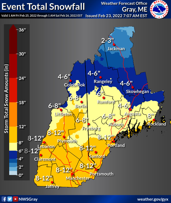
This map shows the general range of snowfall amounts for this storm.
Fool’s Spring is about to come to a screeching halt.
The heavy rain from yesterday and last night has pushed out, and that may lead to ice jams and potentially swollen rivers into tonight as today’s temperatures soar into the 60s!
Enjoy it if this is your thing. It will be a long time before we see another spring-like day…
After cold air returns on a very strong west wind Wednesday night and Thursday, a very promising snowstorm is likely to make an all-day appearance on Friday.
There has been very high confidence in this storm, which has made itself known in model runs dating back to mid-week last week. That doesn’t mean 100% assurance, but pretty high confidence. (Let’s say 99.9999999%.) Winter storm watches have already been posted–again, a sign of the confidence in this forecast–for the entire state of New Hampshire
I anticipate these switching over to winter storm warnings early tomorrow.
Winter Storm Oaklee will move into the Granite State (south to north) early Friday morning. Right now the storm is developing over central Texas and will head northward throughout the day tomorrow. The first flakes should begin to fly just after midnight tomorrow night. By dawn on Friday, snow will be coming down moderate to heavy.
Snowfall looks to be heaviest from dawn to early afternoon. There will be snow bands that set up where an 1-2 inches per hour could accumulate. There could be a period of mixing (sleet or freezing rain) in southern New Hampshire, though I don’t think the mixed precipitation will get close to Concord.
Looks like all snow: light, fluffy snow at that! The snow will lighten up in the mid-afternoon and taper off to snow showers and flurries Friday evening.
As for the bands of snow, this storm is going to take on the appearance of what is called a double-barrel low: two areas of low pressure within the same weather system. One main low pressure center is better for overall storm development than two separate identities.
The two separate lows will create an area of convergence over central New England where snowfall rates will intensify. Many models indicate Vermont and New Hampshire are where those snow bands will predominantly be found.
The storm will not be a super strong or powerful system. The energy for the storm (over the Great Lakes) will lag far behind the moisture feed (over the ocean) and the two will never really fuse together. This isn’t going to be the nor’easter of the century, but a sizable, plowable snow storm nonetheless.
Winds will be out of the northeast but at a speed of 10-15 mph which isn’t all that strong compared to storms we encountered earlier this season.
This is a difficult thing to nail down this far out in advance, but I think this is fairly accurate. It will be cold on Friday with highs in the lower 20s! Colder air increases the “fluff factor” of snow and allows it to pile up to greater depths. This is not going to be that sleety, sloppy sludge we had in early February.
When all is said and done, Concord should have 10-12 inches of fresh snow on the ground.
The long-range forecast has the cold air lingering for the next 6-10 days with below average precipitation, meaning Oaklee is the last storm in the pipeline for a while.
The snow isn’t going to melt or disappear too quickly for those itching to hit the slopes or trails next week, but don’t expect a fresh coating (more than a dusting here or there) for the next 6-10 days.
Statistically, February has been warmer and wetter than normal thanks to Fool’s Spring so the climate models have been on par with their predictions (just in case some are still hanging their hat on the prophecies of a book or the shadow of a Pennsylvania rodent).